• Skip to Content
  • Skip to Main Navigation
  • Skip to Search

Indiana University Indianapolis Indiana University Indianapolis IU Indianapolis

Open Search
  • About
    • People
      • Staff
      • Affiliates
      • Partners
      • Advisory Board
    • Contact Us
  • Research
    • Algal Toxicology
      • Cyanotoxin Fact Page
    • Fluvial Erosion Hazards
    • Edge of Field Monitoring
    • Watershed Monitoring
    • Ecosystem Restoration
      • Lilly ARBOR
        • Urban Floodplain Restoration
        • Project Planning
        • Experimental Design
        • Participant List
        • References
      • Pleasant Run
      • Ritchey Woods
        • Maps
      • Crooked Creek
      • Goose Pond
      • Pogue's Run
      • Southwestway Park
        • Seep Wetland Inventory
      • Starling Nature Sanctuary
        • Maps
    • Past Projects
    • Publications and Presentations
      • Water Resources
      • Restoration
      • Geoinformatics
      • Education and Outreach
      • Service Learning
  • Education Programs
    • K-12
      • Mobile STEM Programs
      • Professional Development Institute
      • DSE Inquiry
      • Teacher Resources
    • Environmental Professionals
    • Community
  • Service Learning
    • Current Projects & Events
      • More Project Information
      • All Project Sites
      • Our Community Partners
      • DIY Projects
      • Other Service Opportunities
    • What to Expect
    • Register
    • Reflective Essay
      • Topical Resources
    • Faculty Sign-Up
    • FAQ
    • Information and Resources
  • News
  • Scholarships
  • Jobs

Center for
Earth and Environmental Science

  • Home
  • About
    • People
    • Contact Us
  • Research
    • Algal Toxicology
    • Fluvial Erosion Hazards
    • Edge of Field Monitoring
    • Watershed Monitoring
    • Ecosystem Restoration
    • Past Projects
    • Publications and Presentations
  • Education Programs
    • K-12
    • Environmental Professionals
    • Community
  • Service Learning
    • Current Projects & Events
    • What to Expect
    • Register
    • Reflective Essay
    • Faculty Sign-Up
    • FAQ
    • Information and Resources
  • News
  • Search
  • Scholarships
  • Jobs
  • Home
  • News & Events
  • News - Manual
  • Using LIDAR to improve fluvial erosion hazard (FEH) mapping

Using LIDAR to improve fluvial erosion hazard (FEH) mapping

Tuesday, February 12, 2013
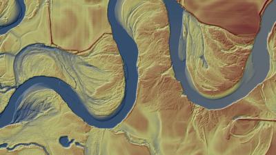
A major source of flood losses is damage to roads, bridges, and other infrastructure caused by fluvial or river erosion - where flood waters erode stream and river banks or even change course, shifting where they flow across the landscape. A challenge working with fluvial systems has been predicting where a shift will occur. We are developing a data fusion approach to access the sensitivity of FEH in different physiographic regions of Indiana through the use of in situ and remote sensor data. Specifically the 2011-2013 Indiana Orthophotography, LiDAR, and Elevation Dataset (IMAGIS), and alluvial soil layers generated by the Natural Resources Conservation Service (NRCS). These data provide a tremendous amount of information allowing us to determine where the stream might potentially erode at both the watershed and stream reach scale.

  • Staff

Contact information, additional links and resources

  • Navigation
  • Home
  • About
  • Research Projects
  • Education Programs
  • Service Learning
  • News
  •  
  • Related websites
  • School of Science
  • Department of Earth and Environmental Sciences
  •  
  • Support CEES
Give Now button
  •  
  • CEES is a proud Ambassador of Weather-Ready Nation, a program of the National Oceanic and Atmospheric Administration.

Center for Earth and Environmental Science (CEES)IU Indianapolis

723 West Michigan Street
Room SL 118
Indianapolis, IN 46202

Phone: (317) 278-1160
Email: cees@iu.edu
  • Twitter
  • Facebook

Indiana University

Accessibility | College Scorecard | Open to All | Privacy Notice | Copyright © 2025 The Trustees of Indiana University